


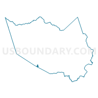
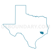
Voting District 0627, Harris County, Texas
About
Outline

Summary
| Unique Area Identifier | 673715 |
| Name | Voting District 0627 |
| County | Harris County |
| State | Texas |
| Area (square miles) | 1.16 |
| Land Area (square miles) | 1.16 |
| Water Area (square miles) | 0.00 |
| % of Land Area | 100.00 |
| % of Water Area | 0.00 |
| Latitude of the Internal Point | 29.66051040 |
| Longtitude of the Internal Point | -95.57390520 |
Maps

Graphs
Select a template below for downloading or customizing gragh for Voting District 0627, Harris County, Texas


Neighbors
Neighoring Voting District (by Name) Neighboring Voting District on the Map
- Voting District 0359, Harris County, TX
- Voting District 0429, Harris County, TX
- Voting District 0462, Harris County, TX
- Voting District 0556, Harris County, TX
- Voting District 0649, Harris County, TX
- Voting District 2140, Fort Bend County, TX
- Voting District 3022, Fort Bend County, TX
Top 10 Neighboring County Subdivision (by Population) Neighboring County Subdivision on the Map
- Houston CCD, Harris County, TX (3,075,388)
- Sugar Land CCD, Fort Bend County, TX (248,350)
- Stafford-Missouri City CCD, Fort Bend County, TX (131,732)
Top 10 Neighboring Place (by Population) Neighboring Place on the Map
Top 10 Neighboring Unified School District (by Population) Neighboring Unified School District on the Map
- Fort Bend Independent School District, TX (348,526)
- Alief Independent School District, TX (256,592)
- Stafford Municipal School District, TX (17,095)
Top 10 Neighboring State Legislative District Lower Chamber (by Population) Neighboring State Legislative District Lower Chamber on the Map
- State House District 26, TX (180,729)
- State House District 149, TX (169,836)
- State House District 133, TX (155,296)
- State House District 131, TX (152,889)
Top 10 Neighboring State Legislative District Upper Chamber (by Population) Neighboring State Legislative District Upper Chamber on the Map
Top 10 Neighboring 111th Congressional District (by Population) Neighboring 111th Congressional District on the Map
Top 10 Neighboring Census Tract (by Population) Neighboring Census Tract on the Map
- Census Tract 4534.02, Harris County, TX (8,214)
- Census Tract 4532, Harris County, TX (7,947)
- Census Tract 4536.02, Harris County, TX (7,699)
- Census Tract 4401, Harris County, TX (6,751)
- Census Tract 4535.01, Harris County, TX (6,174)
- Census Tract 6719, Fort Bend County, TX (4,130)
- Census Tract 4534.01, Harris County, TX (3,125)
- Census Tract 6718, Fort Bend County, TX (3,011)
- Census Tract 4533, Harris County, TX (2,965)